Friday, May 6, 2011

Chapter 10 – The Southern Coastlands: On the Subtropical Margin


The Southern Coastlands is an area that is not seen commonly in the United States. This area is humid and subtropical. The Gulf of Mexico has warm waters that give the region’s climate a balmy, maritime feel.[1]
So how does a pretty close to tropical area compare to the constantly overcast weather of Seattle?
Surprisingly, there are a few things that these two areas have in common such as the amount of annual precipitation, the importance of their seaports, and their large percentage of immigrant population.
Let’s begin with precipitation. Contrary to popular belief, Seattle gets less rain than the Southern Coastlands. The Coastlands receive about 50 inches of rainfall per year as opposed to Seattle that receives an average of 37 inches per year.[2] Even though the southern coastlands get more rain than the Seattle area, they both still get a considerable amount of precipitation.
Both areas have very large and important seaports that are an integral part of the U.S. economy.
Above image is of the Port of New Orleans, courtesy of shipdetective.com
The Port of Seattle supported nearly 200,000 jobs in the Puget Sound region in 2003. Similarly, the Port of New Orleans is responsible for approximately 160,498 jobs.[3]
Seattle’s port generated more than $12 billion in business revenue and $626 million in state and local taxes. According to a 2004 study, the Port of New Orleans generated $8 billion in earnings and $800 million in taxes statewide.[4]
Seattle’s port is the nation’s 6th busiest seaport, ranking among the top 50 ports globally. China is the port’s largest trading partner, followed by Japan, South Korea, Taiwan, and Thailand.[5] New Orleans’ port is known to be the world’s busiest waterway. More than 6,000 ocean vessels annually move through New Orleans on the Mississippi River.[6]
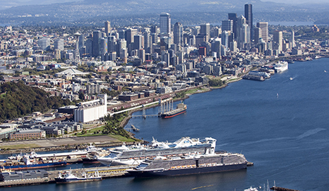
Above image is of the Port of Seattle, courtesy of prowsedge.com
Finally, we come to the racial diversity of both areas. For the Southern Coastlands we will look at Miami, Florida and compare to of course Seattle, Washington.
Within the Miami city limits, the population was approximately 362,470 in 2000. Sixty-five percent of those people were Latino and among those Latinos, about 35% were of Cuban descent.[7] Asians comprised less than 1% of the population, compared to Seattle, where 13% are of Asian descent and 70% are White. Latinos only comprise about 5% of Seattle’s population.[8]
Cuban-Americans in Miami, courtesy of nytimes.com


[1] Stephen S. Birdsall, Eugene J. Palka, Jon C. Malinowski, and Margo L. Price, Regional Landscapes of the United States and Canada 7th Edition (Wiley, 2008), 190.
[2] “See Seattle Northwest Weather,” accessed May 1, 2011. http://www.see-seattle.com/weather.htm.
[3] “Port of Seattle Quick Facts,” accessed May 1, 2011. www.portseattle.org/downloads/about/Quick_Facts2008_1.pdf.
[4] “Port of New Orleans Facts,” accessed May 1, 2011. http://www.portno.com/pno_pages/about_overview.htm.
[5] “Port of Seattle Quick Facts.”
[6] “Port of New Orleans Facts.”
[7] “Ethnicity Statistics,” last modified 2000, http://www.ersys.com/usa/12/1245000/ethnic.htm.
[8] “Seattle Population and Demographics,” last modified 2000, http://seattle.areaconnect.com/statistics.htm.

Sunday, March 20, 2011

Come On In!


The Changing South
There are a few things that the South and the Seattle area have in common such as the constant precipitation and its industry in paper products, but the one thing that grabbed my attention was the differences in the architectural styles of housing.
In Seattle, there are a few styles that predominate, those are the Victorian, the Craftsman, and more uniquely, the Water home.


 FUN FACT: Seattle has the highest percentage of water homes in the United States, second highest outside of Asia.

In New Orleans, the styles that predominate are the Creole Cottage, the Shotgun house, and the Double-Gallery house.


All of these styles accommodate the climate of each city, the type of terrain, and they also show the ethnicities that settled into each area.

Home on the Ranges


There aren’t a lot of similarities between the Appalachian Mountains area and the Seattle area but Washington does have a mountain range the goes through the state, the range is called the Cascades. The Cascade Range stretches over 700 miles across Northern California, Oregon, Washington, and Southern British Columbia, running parallel to the Pacific, about 100-150 miles inland. The range is best known for its massive snow-capped volcanoes, which rise in isolation and are separated by great intervening plateaus.[1]

On the other hand, the Appalachians are twice as long in length compared to the Cascade Range. At about 1,500 miles in length, they extend from central Alabama up through the New England states and the Canadian provinces of New Brunswick, Newfoundland and Quebec.
The Appalachians might be lengthier, but they are not higher than the Cascades. The highest point in the Appalachians is Mt. Mitchell in North Carolina at 6,684 feet.[2] As opposed to the highest point in the Cascades which is Mt. Rainier at 14,410 feet.


[1] “Cascade Range,” accessed March 20, 2011, http://www.peakware.com/areas.html?a=293
[2] “Landforms of North America,” accessed March 20, 2011, http://www.worldatlas.com/webimage/countrys/nalnd.htm

Seattle's Forgotten Siblings to the East


The Bypassed East
How does a state that is in the Pacific Northwest compare with other states that are in the Atlantic Northeast?
Well, it turns out there are many similarities and many differences at the same time.
One similarity is that both areas consist of large forestlands.
This is a picture of a forest in Maine and the bottom one is from Washington, they're similar but the Washington forest has moss covering the trees.


Washington State has approximately 21 million acres of forested land.[1] New Hampshire is the second most forested state (in terms of percentage) in the United States, the land is 84% forestland with 4.8 million acres.[2] Maine is the most forested state in the nation with 17.7 million acres of forest land that is over 90% of the state.[3]
One difference is the population and urban areas of each area…
The largest city in Maine is Portland with a population of about 64,000.[4] Vermont’s largest city is Burlington with a population of about 39,000.[5] Manchester is the largest city in New Hampshire with 110,000 people.[6] If we were to add these three cities together they still would not even be half of Seattle’s population. 
Mt. Rainier is at top and Mt. Washington is at bottom:


Even though both areas have different elevations and many different mountains Washington’s famous Mt. Rainier is more than double the size of Mt. Washington in New Hampshire. Mount Rainier is 14,410 feet high compared to Mount Washington at 6,288 feet high.[7]


[1] “Forestlands in Washington Counties,” accessed March 20, 2011, http://www.mrsc.org/subjects/environment/forest/timber.aspx.
[2] “Forest Statistics,” accessed March 20, 2011, http://www.nhdfl.org/forest-industries-and-business/forest-statistics.aspx.
[3] “Who Owns Maine’s Forest?,” accessed March 20, 2011, http://www.mainetreefoundation.org/forestfacts/Who%20Owns%20Maine%27s%20Forest.htm.
[4] “City of Portland, Maine,” accessed March 20, 2011, http://www.portlandmaine.gov/
[5] “Vermont Indicators Online,” accessed March 20, 2011, http://maps.vcgi.org/indicators/cfhome/town_profile.cfm?Call_Program=INDICATORS&ProfileTown=Burlington.
[6] “Biggest Cities New Hampshire,” accessed March 20, 2011, http://www.geonames.org/US/NH/largest-cities-in-new-hampshire.html.
[7] “Highest Points in the United States,” accessed March 20, 2011, http://geology.com/state-high-points.shtml.

Friday, March 18, 2011

Manufacturing in Seattle? Well, Not Exactly


The North American Manufacturing Core
The Seattle area is home to many industries including aerospace, information and communication technology, clean energy, biotechnology and marine technology.[1]Seattle is also famously known for its coffee, Starbuck’s and Seattle’s Best Coffee are the best known but there are also smaller roasters such as Tully’s, Caravali Coffees, and Lighthouse Roasters to name a few.


FUN FACT: The Washington, more specifically Seattle area, has the highest per capita share of technology-dependent jobs among all the states in the country and it’s not just all Microsoft either, you can’t turn a corner without bumping into a technology based business.[2]
So where do these techies all hyped up on coffee go shopping for their black framed glasses and plaid shirts?...The Westfield Southcenter Shopping Mall of course!
The Southcenter mall is the biggest shopping center in the Pacific Northwest. It is over 5 million square feet![3]


[1] “The Greater Seattle Datasheet,” accessed March 18, 2011, http://www.cityofseattle.net/oir/datasheet/economy.htm.
[2] Whiting, J. (2011). Seattle Trivia & Fun Facts. http://www.jetcityorange.com/Seattle/Seattle-trivia.html (16 Mar. 2011).
[3] “Shops – Seattle Southside,” accessed March 18, 2011, http://www.seattlesouthside.com/shops.

Not Really a Megalopolis, but Close


So, what is a megalopolis and is Seattle part of one?
A megalopolis is an urbanized region that is dominated by a chain of large, densely populated metropolitan areas that have coalesced over time to produce even larger conurbations.[1]
The term megalopolis is used to refer to the areas of New York City and its surrounding cities such as, Boston, Washington D.C., Baltimore and Philadelphia, to name a few. So, in essence, Seattle cannot be part of megalopolis, but it is part of a large urban metropolitan area.
Location, location, location…hey, it’s important!

FUN FACT: Seattle's Harbor Island is the largest man made island in the nation.[2]
There are several reasons why a city grows in size and in population, the main reason is the site characteristics. The site characteristics refer to the physical features that make up the immediate environment of that place’s location.[3]

As illustrated by the chart, there have been ups and downs in Seattle’s population, it happens to a lot of cities.
This is the view from the Bank of America building in Downtown Seattle.

FUN FACT: The Washington State Ferry System is the largest in the country and the third largest in the world, carrying over 25 million passengers annually. Seattle's Pier 52 is the busiest ferry terminal in the U.S.[4]
Because of Seattle’s proximity to Asia, the Port of Seattle trades with many Asian countries, the top five include: China, Japan, Taiwan, South Korea, and Vietnam.


[1] Stephen S. Birdsall, Eugene J. Palka, Jon C. Malinowski, and Margo L. Price, Regional Landscapes of the United States and Canada 7th Edition (Wiley, 2008), 64.
[2] Whiting, J. (2011). Seattle Trivia & Fun Facts. http://www.jetcityorange.com/Seattle/Seattle-trivia.html (18 Mar. 2011).
[3] Birdsall, Palka, Malinowski, and Price, Landscapes of the U.S. and Canada, 66.
[4] “Seattle Trivia & Fun Facts,” accessed March 18, 2011.

It’s All About the Humans!


Seattle's Foundations of Human Activity

Some scientists speculate that humans began to inhabit the North American continent about 12,000 years ago.[1]
Before European settlement, peoples of several tribes and bands inhabited the Seattle/Puget Sound area. The Suquamish and Duwamish tribes were the most populous.
Chief Seattle (or Sealth) was a hereditary leader of the Suquamish Tribe. He was born around 1786 and died on June 7, 1866. Seattle is remembered for accommodating the early Anglo-European settlers of Alki Point (later West Seattle), and as a negotiator/peacemaker. This is why the city was named after this great Native leader.[2]
Nowadays Seattle is more diverse ethnically but not as much as other major U.S. cities…

Nearly three quarters of Seattleites are white.
People of Asian descent comprise Seattle's second largest racial group.
Thirteen percent of Seattleites selected Asian to identify themselves in the 2000 census.
Comparatively, in the United States, 3.6 percent of the population is of Asian descent and another 0.6 percent of the population identified themselves as at least two races including Asian.[3]

Seattle is located on an area if primary growth. Despite this, the metropolitan area population growth fell to 13 percent in the 2000s compared to 19 percent growth in the 1990s. Nonetheless, the historical core municipality of Seattle grew 8 percent between 2000 and 2010 (from 563,000 to 608,000), while the suburbs grew 14 percent. The suburbs attracted 89 percent of the metropolitan population growth.[4]
Seattle is ranked the 15th largest city in the United States in 2000.[5]
The predominant religion in the Seattle metropolitan area is Christianity, but because of Seattle’s diverse communities other practiced religions are Hinduism, Confucianism, Buddhism and Islam. This is because of the area’s abundant Asian population.[6]


[1] Stephen S. Birdsall, Eugene J. Palka, Jon C. Malinowski, and Margo L. Price, Regional Landscapes of the United States and Canada 7th Edition (Wiley, 2008), 44.
[2] “Suquamish Indian Tribe,” accessed March 17, 2011, http://www.u-s-history.com/pages/h1576.html
[3] “Seattle’s Population & Demographics,” last modified January 15, 2005, http://www.seattle.gov/dpd/Research/Population_Demographics/Prior_Censuses/1900-2000_Population_Housing_Trends/DPDS_007030.asp.
[4] Wendell Cox, “Slowing Growth Rates & Convergence,” New Geography, February 24, 2011, accessed March 17, 2011, http://www.newgeography.com/content/002073-seattle-denver-portland-slowing-growth-rates-convergence.
[5] Birdsall, Palka, Malinowski, and Price, Landscapes of the U.S. and Canada, 56.
[6] “Religion in Seattle,” last modified 2008, http://www.mapsofworld.com/cities/usa/seattle/religion.html.